 VLIZ Geonetwork
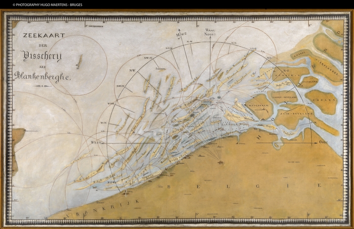
Zeekaart der Visscherij van Blankenberghe
The "De “Zeekaart der Visscherij van Blankenberge" was created between 1889 and 1900 by E.H.G. Carlier. This chaplain of the Saint-Rochus parish of Blankenberge was the first principal of the Vrije Visserijschool (Free School of Fishing) in this coastal commune. The painted "Zeekaart" of Carlier, which was developed based on English seamaps, contained a lot of toponyms which are long gone. These toponyms were common knowledge amongst the fisherman of those days. A picture of the 'Zeekaart' in small form factor was used in the Fisher School as a didactic aid to help students orient themselves at sea. Even today the map can still be admired as it is a unique piece in regard to its design and coastal toponyms of the Belgian coast. It endured the test of time remarkably well and still belongs to the patrimonium of the Saint Peter's college.
More information: <a href=" http://www.vliz.be/hisgiskust/sites/vliz.be.hisgiskust/files/public/documenten/Lodewijkbank.pdf" target="_blank">Grote Rede (2010) - Zeewoorden, Lodewijkbank</a>
Simple
- Date (Revision)
- 2017-01-11
- Citation identifier
- Zeekaart_Vis_Bl
- Cited responsible party
-
Organisation name Individual name Electronic mail address Role Vlaams Instituut voor de Zee (VLIZ)
Owner
- Presentation form
- Digital map
- Point of contact
-
Organisation name Individual name Electronic mail address Role Vlaams Instituut voor de Zee
Point of contact
- Keywords
-
-
{hgauth}E.H. Carlier, G.
-
{hgloc}Belgian Coast
-
{hgloc}English Coast
-
{hgloc}Belgian East Coast
-
{hgloc}Belgian West Coast
-
{hgloc}North Sea
-
{hgloc}
-
{hgtheme}Flemish Banks
-
{hgtheme}Fishing map
-
{hgcent}19° century
-
{hglang}Dutch
-
{hgid}Zeekaart_Vis_Bl
-
{picid}111864
-
{hgdistid}119134
-
{hgowner}<a href=" http://www.vliz.be/" target="_blank">Flanders Marine Institute</a>
-
Citation: HisGISKust; Flanders Marine Institute (2016) Zeekaart der Visscherij van Blankenberghe ( http://geonetwork.vliz.be/geonetwork/srv/eng/catalog.search#/metadata/03c9b831-3f4c-46ce-83a8-53b052c66326)
-
- Keywords
-
- Use limitation
-
no limitations
- Access constraints
- Other restrictions
- Use constraints
- Other restrictions
- Classification
- Unclassified
- Spatial representation type
- Vector
- Denominator
- 237100
- Language
- Nederlands; Vlaams
- Character set
- UTF8
- Topic category
-
- Geoscientific Information
))
- Reference system identifier
- http://www.opengis.net/def/crs/EPSG/0/3857
- Distribution format
-
Name Version tiff
1
- Distributor contact
-
Organisation name Individual name Electronic mail address Role Flanders Marine Institute (VLIZ)
Distributor
Digital transfer options
- OnLine resource
-
Protocol Linkage Name http://www.vliz.be/hisgiskust OGC:WMS-1.1.1-http-get-map
http://geo.vliz.be:80/geoserver/HistorischeKaarten/ows?SERVICE=WMS& Zeekaart_Vis_Bl
- Hierarchy level
- Dataset
Conformance result
- Title
-
COMMISSION REGULATION (EU) No 1089/2010 of 23 November 2010 implementing Directive 2007/2/EC of the European Parliament and of the Council as regards interoperability of spatial data sets and services
- Alternate title
-
INSPIRE Data Specification
- Date (Publication)
- 2010-12-08
- Explanation
-
INSPIRE Data Specification
- Pass
- No
- Statement
-
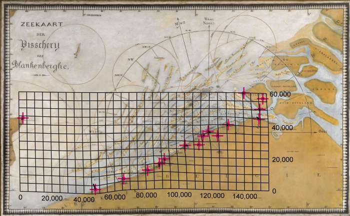
1) Scanning
2) Georeference:
Transformation type: Thin Plate Spline
Sampling method: Nearest neighbour
Background layer: OpenStreetMap
Coordinate system: WGS 84/ Pseudo Mercator (EPSG: 3857)
Ground control points: 16
Mapanalyst:
Scale: 237100
Rotation: 0deg; cw
Standard deviation: ca. 973 m
Mean Position Error: ca. 1376 m
Transformation: Helmert 4 parameters
Metadata
- File identifier
- 03c9b831-3f4c-46ce-83a8-53b052c66326 XML
- Metadata language
- Nederlands; Vlaams
- Character set
- UTF8
- Hierarchy level
- Dataset
- Date stamp
- ####
- Metadata standard name
-
ISO19115
- Metadata standard version
-
2003/Cor.1:2006
- Metadata author
-
Organisation name Individual name Electronic mail address Role Flanders Marine Institute (VLIZ)
Point of contact
- Other language
-
Language Character encoding English UTF8 Dutch; Flemish UTF8
)))