 VLIZ Geonetwork
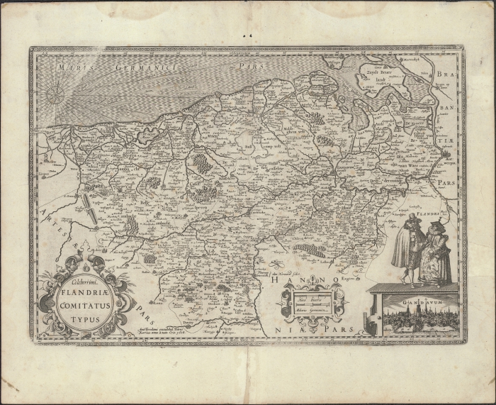
Celeberrimi Flandriae comitatus typus
Celeberrimi Flandriae comitatus typus
In het kader van het initiatief HisGISKust werd een samenwerkingsovereenkomst afgesloten tussen het Vlaams Instituut voor de Zee (VLIZ) en Cultuurbibliotheek (Brugge). Hierbij werden historische kaarten geselecteerd uit de collectie van de Cultuurbibliotheek die specifieke informatie bevatten over de kustzone (duinen, dijken, etc.), het Schelde-estuarium en/of het Belgisch deel van de Noordzee (BNZ) (zandbanken, aanduiding bathymetrie, etc.). De kaarten werden door het VLIZ gedigitaliseerd en gegeorefereerd teneinde deze samen met de nodige metadata in open access aan te bieden aan eindgebruikers. Op basis van de gegeorefereerde kaarten worden ook shapefiles (bv. de kustlijn, duingebieden, etc.) gegenereerd en vrij ter beschikking gesteld.
In the framework of the initiative HisGISKust, a collaboration agreement was established between Flanders Marine Institute (VLIZ) and Cultuurbibliotheek (Bruges). Historic maps from the collection of Cultuurbibliotheek with specific information about the coastal zone, Scheldt Estuary and/or the Belgian part of the North Sea were selected. These maps were digitized and georeferenced by VLIZ and are disclosed in open access to end users together with the appropriate metadata. Based on the georeferenced maps, shapefiles were generated as well (e.g. coastline, dune area, etc.).
Simple
-
Date (Revision)Datum (revisie)
- 2016-03-01
-
Citation identifierIdentifier
- K3_52_2007_462
- Cited responsible party
-
Organisation name Individual name Electronic mail address Role Vlaams Instituut voor de Zee (VLIZ)
Vlaams Instituut voor de Zee (VLIZ)
Ownereigenaar
-
Presentation formWijze van presentatie
-
Digital mapmapDigital
- Point of contact
-
Organisation name Individual name Electronic mail address Role Cultuurbibliotheek
Cultuurbibliotheek
Point of contactcontactpunt
- Keywords
-
-
{hgauth}Kaerius, Petrus
{hgauth}Kaerius, Petrus
-
{hgloc}Belgische Kust
{hgloc}Belgian Coast
-
{hgloc}Oostkust
{hgloc}Belgian East Coast
-
{hgloc}Westkust
{hgloc}Belgian West Coast
-
{hgloc}Schelde
{hgloc}Scheldt
-
{hgloc}Westerschelde
{hgloc}Western Scheldt
-
{hgloc}Zandbanken
{hgloc}Sandbanks
-
{hgtheme}Vlaamse Banken
{hgtheme}Flemish Banks
-
{hgcent}17° eeuw
{hgcent}17° century
-
{hglang}Latijn
{hglang}Latin
-
{hgid}K3_52_2007_462
{hgid}K3_52_2007_462
-
{picid}111619
{picid}111619
-
{hgdistid}111977
{hgdistid}111977
-
{hgowner}<a href=" http://www.cultuurbibliotheek.be/" target="_blank">Cultuurbibliotheek</a> (verwerkt door <a href=" http://www.vliz.be" target="_blank">VLIZ</a>)
{hgowner}<a href=" http://www.cultuurbibliotheek.be/" target="_blank">Cultuurbibliotheek</a> (processed by <a href=" http://www.vliz.be" target="_blank">VLIZ</a>)
-
{hgshapekustlijn}
{hgshapekustlijn}
-
Citatie: HisGISKust; Cultuurbibliotheek (verwerkt door VLIZ) (2016) Celeberrimi Flandriae comitatus typus ( http://geonetwork.vliz.be/geonetwork/srv/dut/catalog.search#/metadata/111ff092-219e-42bb-9e24-ce44ca2de266)
Citation: HisGISKust; Cultuurbibliotheek (processed by VLIZ) (2016) Celeberrimi Flandriae comitatus typus ( http://geonetwork.vliz.be/geonetwork/srv/eng/catalog.search#/metadata/111ff092-219e-42bb-9e24-ce44ca2de266)
-
- Keywords
-
-
GebruiksbeperkingenUse limitation
-
no limitations
no limitations
-
Access constraints(Juridische) toegangsrestrictie
-
Other restrictionsanders
-
Use constraints(Juridische) gebruiksbeperking
-
Other restrictionsanders
-
ClassificationVeiligheidsrestricties
-
Unclassifiedvrij toegankelijk
-
Spatial representation typeRuimtelijk schema
-
Vectorvector
-
DenominatorToepassingsschaal
- 391600
-
LanguageTaal
- Nederlands; Vlaams
-
Character setKarakterset
-
UTF8utf8
-
Topic categoryOnderwerp
-
-
Geoscientific InformationGeoscientific Information
-
))
-
Reference system identifierReferentiesysteem identifier
-
http://www.opengis.net/def/crs/EPSG/0/3857http://www.opengis.net/def/crs/EPSG/0/3857
- Distribution format
-
Name Version tiff
tiff
1
- Distributor contact
-
Organisation name Individual name Electronic mail address Role Vlaams Instituut voor de Zee (VLIZ)
Flanders Marine Institute (VLIZ)
Distributordistributeur
Digital transfer options
Digitale leverings opties
- OnLine resource
-
Protocol Linkage Name http://www.vliz.be/hisgiskust OGC:WMS-1.1.1-http-get-map
http://geo.vliz.be:80/geoserver/HistorischeKaarten/ows?SERVICE=WMS& K3_52_2007_462
-
Hierarchy levelNiveau kwaliteitsbeschrijving
-
Datasetdataset
Conformance result
Resultaat conformiteit met de specificatie
-
TitelTitle
-
COMMISSION REGULATION (EU) No 1089/2010 of 23 November 2010 implementing Directive 2007/2/EC of the European Parliament and of the Council as regards interoperability of spatial data sets and services
COMMISSION REGULATION (EU) No 1089/2010 of 23 November 2010 implementing Directive 2007/2/EC of the European Parliament and of the Council as regards interoperability of spatial data sets and services
-
Alternatieve titelAlternate title
-
INSPIRE Data Specification
INSPIRE Data Specification
-
Date (Publication)Datum (publicatie)
- 2010-12-08
-
UitlegExplanation
-
INSPIRE Data Specification
INSPIRE Data Specification
-
PassIndicatie van conformiteit met de specificatie
- No
-
Algemene beschrijving herkomstStatement
-
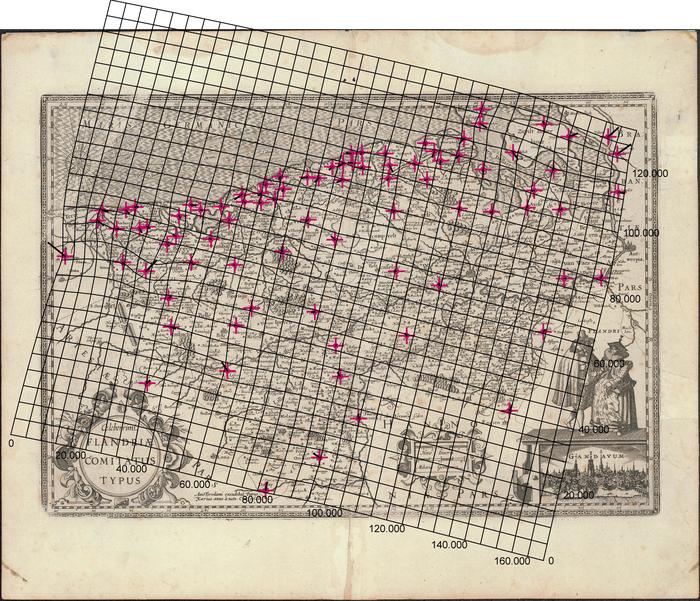
1) Inscannen kaart
2) Georefereren:
Transformatietype: Thin Plate Spline
Samplingmethode: Nearest neighbour
Achtergrondkaart: OpenStreetMap
Coordinaatsysteem: WGS 84/ Pseudo Mercator (EPSG: 3857)
Grondcontrolepunten: 85
3) Mapanalyst:
Schaal: 391600
Rotatie: 13deg; cw
Standaarddeviatie: ca. 1176 m
Mean Position Error: ca. 1663 m
Transformatie: Helmert 4 parameters
1) Scanning
2) Georeference:
Transformation type: Thin Plate Spline
Sampling method: Nearest neighbour
Background layer: OpenStreetMap
Coordinate system: WGS 84/ Pseudo Mercator (EPSG: 3857)
Ground control points: 85
Mapanalyst:
Scale: 391600
Rotation: 13deg; cw
Standard deviation: ca. 1176 m
Mean Position Error: ca. 1663 m
Transformation: Helmert 4 parameters
Metadata
-
File identifierMetadata ID
- 111ff092-219e-42bb-9e24-ce44ca2de266 XML
-
Metadata languageTaal
- Nederlands; Vlaams
-
Character setKarakterset
-
UTF8utf8
-
Hierarchy levelHierarchisch niveau
-
Datasetdataset
-
Date stampMetadata datum
- ####
- Metadata standard name
-
ISO19115
- Metadata standard version
-
2003/Cor.1:2006
- Metadata author
-
Organisation name Individual name Electronic mail address Role Vlaams Instituut voor de Zee (VLIZ)
Flanders Marine Institute (VLIZ)
Point of contactcontactpunt
- Other language
-
Language Character encoding EnglishEngelsUTF8utf8Dutch; FlemishNederlands; VlaamsUTF8utf8
)))