 VLIZ Geonetwork
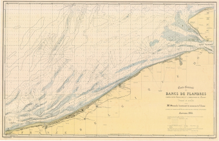
Carte Générale des Bancs de Flandres compris entre Gravelines et l'embouchure de l'Escaut
Standaard
- Datum (revisie)
- 2017-01-18
- Identifier
- Stessels_1866
- Geciteerde verantwoordelijke partij
-
Organisatie Naam Contactpersoon Email Rol Vlaams Instituut voor de Zee (VLIZ)
eigenaar
- Wijze van presentatie
- mapDigital
- Contactgegevens voor de data
-
Organisatie Naam Contactpersoon Email Rol Vlaams Instituut voor de Zee
contactpunt
- Trefwoorden
-
-
{hgauth}Stessels, A.
-
{hgloc}Belgische Kust
-
{hgloc}Oostkust
-
{hgloc}Westkust
-
{hgloc}Zandbanken
-
{hgloc}Noordzee
-
{hgloc}
-
{hgtheme}Bathymetrische informatie
-
{hgtheme}Nautische kaart
-
{hgtheme}Vlaamse Banken
-
{hgcent}19° eeuw
-
{hglang}Frans
-
{hgid}Stessels_1866
-
{picid}15526
-
{hgdistid}
-
{hgowner}<a href=" http://www.vliz.be/" target="_blank">Vlaams Instituut voor de Zee</a>
-
Citatie: HisGISKust; Vlaams Instituut voor de Zee (2016) Carte Générale des Bancs de Flandres compris entre Gravelines et l'embouchure de l'Escaut ( http://geonetwork.vliz.be/geonetwork/srv/dut/catalog.search#/metadata/3fec7170-06aa-40cd-b8e2-87a326fd2d2f)
-
- Trefwoorden
-
- Gebruiksbeperkingen
-
no limitations
- (Juridische) toegangsrestrictie
- anders
- (Juridische) gebruiksbeperking
- anders
- Veiligheidsrestricties
- vrij toegankelijk
- Ruimtelijk schema
- vector
- Toepassingsschaal
- -
- Taal
- Nederlands; Vlaams
- Karakterset
- utf8
- Onderwerp
-
- Geoscientific Information
))
- Referentiesysteem identifier
- http://www.opengis.net/def/crs/EPSG/0/3857
- Distributie formaat
-
Naam Versie tiff
1
- Distributeur contact
-
Organisatie Naam Contactpersoon Email Rol Vlaams Instituut voor de Zee (VLIZ)
distributeur
Digitale leverings opties
- OnLine bronnen
-
Protocol URL Naam http://www.vliz.be/hisgiskust OGC:WMS-1.1.1-http-get-map
http://geo.vliz.be:80/geoserver/HistorischeKaarten/ows?SERVICE=WMS& Stessels_1866
- Niveau kwaliteitsbeschrijving
- dataset
Resultaat conformiteit met de specificatie
- Titel
-
COMMISSION REGULATION (EU) No 1089/2010 of 23 November 2010 implementing Directive 2007/2/EC of the European Parliament and of the Council as regards interoperability of spatial data sets and services
- Alternatieve titel
-
INSPIRE Data Specification
- Datum (publicatie)
- 2010-12-08
- Uitleg
-
INSPIRE Data Specification
- Indicatie van conformiteit met de specificatie
- Nee
- Algemene beschrijving herkomst
-
1) Inscannen kaart
2) Georefereren:
Transformatietype: Thin Plate Spline
Samplingmethode: Nearest neighbour
Achtergrondkaart:
Coordinaatsysteem: WGS 84 (EPSG:4326)
Grondcontrolepunten: 52
3) Mapanalyst:
Schaal: -
Rotatie: -
Standaarddeviatie: -
Mean Position Error: -
Transformatie: -
Metadata
- Metadata ID
- 3fec7170-06aa-40cd-b8e2-87a326fd2d2f XML
- Taal
- Nederlands; Vlaams
- Karakterset
- utf8
- Hierarchisch niveau
- dataset
- Metadata datum
- ####
- Metadata standaard naam.
-
ISO19115
- Metadata standaard versie
-
2003/Cor.1:2006
- Metadata auteur
-
Organisatie Naam Contactpersoon Email Rol Vlaams Instituut voor de Zee (VLIZ)
contactpunt
- Landinstelling
-
Taalcode Tekencodering Engels utf8 Nederlands; Vlaams utf8

)))