 VLIZ Geonetwork
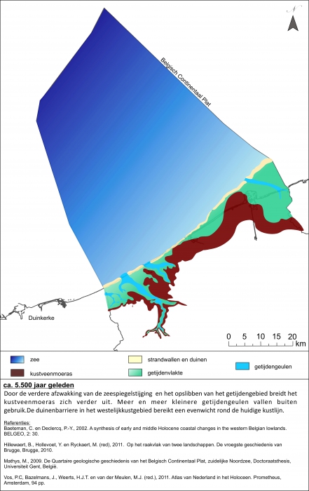
Paleogeografische reconstructie 5500 jaar geleden
This paleogeographic map provides a representation of the position of the coast line on a specific moment in the past. The map was developed in the context of the SEARCH project and is based on the prevailing geological, archaeological and historical information. These reconstructions are work in progress and are continuously revised as a result of new research.
Simple
- Date (Revision)
- 2016-03-01
- Citation identifier
- paleo5500
- Cited responsible party
-
Organisation name Individual name Electronic mail address Role Vlaams Instituut voor de Zee (VLIZ)
Owner
- Presentation form
- Digital map
- Point of contact
-
Organisation name Individual name Electronic mail address Role RCMG
Point of contact
- Keywords
-
-
{hgauth}De Clercq, Maikel (RCMG, Ugent)
-
{hgloc}Belgian Coast
-
{hgtheme}Paleogeographic map
-
{hgcent}-
-
{hglang}
-
{hgid}paleo5500
-
{picid}111868
-
{hgdistid}
-
{hgowner}<a href=" http://www.rcmg.ugent.be/" target="_blank">RCMG</a>
-
{hgshapepaleo}paleo5500
-
Citation: HisGISKust; RCMG (2016) Paleogeografische reconstructie 5500 jaar geleden ( http://geonetwork.vliz.be/geonetwork/srv/eng/catalog.search#/metadata/42d954d4-1985-4a03-b538-521d78c58dec)
-
- Keywords
-
- Use limitation
-
no limitations
- Access constraints
- Other restrictions
- Use constraints
- Other restrictions
- Classification
- Unclassified
- Spatial representation type
- Vector
- Language
- Nederlands; Vlaams
- Character set
- UTF8
- Topic category
-
- Geoscientific Information
))
- Reference system identifier
- http://www.opengis.net/def/crs/EPSG/0/3857
- Distribution format
-
Name Version tiff
1
- Distributor contact
-
Organisation name Individual name Electronic mail address Role Flanders Marine Institute (VLIZ)
Distributor
Digital transfer options
- OnLine resource
-
Protocol Linkage Name http://www.vliz.be/hisgiskust OGC:WMS-1.1.1-http-get-map
http://geo.vliz.be:80/geoserver/HistorischeKaarten/ows?SERVICE=WMS& paleo5500
- Hierarchy level
- Dataset
Conformance result
- Title
-
COMMISSION REGULATION (EU) No 1089/2010 of 23 November 2010 implementing Directive 2007/2/EC of the European Parliament and of the Council as regards interoperability of spatial data sets and services
- Alternate title
-
INSPIRE Data Specification
- Date (Publication)
- 2010-12-08
- Explanation
-
INSPIRE Data Specification
- Pass
- No
- Statement
-
1) Scanning
2) Georeference:
Transformation type:
Sampling method:
Background layer:
Coordinate system:
Ground control points:
Mapanalyst:
Scale: -
Rotation: -
Standard deviation: -
Mean Position Error: -
Transformation: -
Metadata
- File identifier
- 42d954d4-1985-4a03-b538-521d78c58dec XML
- Metadata language
- Nederlands; Vlaams
- Character set
- UTF8
- Hierarchy level
- Dataset
- Date stamp
- 2018-10-31T14:43:03
- Metadata standard name
-
ISO19115
- Metadata standard version
-
2003/Cor.1:2006
- Metadata author
-
Organisation name Individual name Electronic mail address Role Flanders Marine Institute (VLIZ)
Point of contact
- Other language
-
Language Character encoding English UTF8 Dutch; Flemish UTF8

)))