 VLIZ Geonetwork
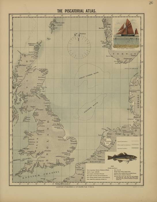
The piscatorial atlas (Olsen, 1883) - Cod
In het kader van het initiatief HisGISKust werden de kaarten van Olsen (1883) (collectie VLIZ) gedigitaliseerd en gegeorefereerd door het VLIZ teneinde deze samen met de nodige metadata in open access aan te bieden aan eindgebruikers. Op basis van de gegeorefereerde kaarten kunnen ook shapefiles (bv. de kustlijn, duingebieden, etc.) gegenereerd worden.
Olsen, O.T. (1883). The piscatorial atlas of the North Sea, English and St. George's Channels, illustrating the fishing ports, boats, gear, species of fish (how, where, and when caught), and other information concerning fish and fisheries. Taylor and Francis: London. 50 maps pp.
Standaard
- Datum (revisie)
- 2017-01-10
- Identifier
- PiscAtl_20
- Geciteerde verantwoordelijke partij
-
Organisatie Naam Contactpersoon Email Rol Vlaams Instituut voor de Zee (VLIZ)
eigenaar
- Wijze van presentatie
- mapDigital
- Contactgegevens voor de data
-
Organisatie Naam Contactpersoon Email Rol Vlaams Instituut voor de Zee
contactpunt
- Trefwoorden
-
-
{hgauth}Olsen, O.T.
-
{hgloc}Noordzee
-
{hgloc}
-
{hgtheme}Visserijkaart
-
{hgcent}19° eeuw
-
{hglang}Engels
-
{hgid}PiscAtl_20
-
{picid}16496
-
{hgdistid}
-
{hgowner}<a href=" http://www.vliz.be/" target="_blank">Vlaams Instituut voor de Zee</a>
-
Citatie: HisGISKust; Vlaams Instituut voor de Zee (2016) The piscatorial atlas (Olsen, 1883) - Cod ( http://geonetwork.vliz.be/geonetwork/srv/dut/catalog.search#/metadata/62db886a-cdf0-404e-bf4d-58b31d7da267)
-
- Trefwoorden
-
- Gebruiksbeperkingen
-
no limitations
- (Juridische) toegangsrestrictie
- anders
- (Juridische) gebruiksbeperking
- anders
- Veiligheidsrestricties
- vrij toegankelijk
- Ruimtelijk schema
- vector
- Toepassingsschaal
- -
- Taal
- Nederlands; Vlaams
- Karakterset
- utf8
- Onderwerp
-
- Geoscientific Information
))
- Referentiesysteem identifier
- http://www.opengis.net/def/crs/EPSG/0/3857
- Distributie formaat
-
Naam Versie tiff
1
- Distributeur contact
-
Organisatie Naam Contactpersoon Email Rol Vlaams Instituut voor de Zee (VLIZ)
distributeur
Digitale leverings opties
- OnLine bronnen
-
Protocol URL Naam http://www.vliz.be/hisgiskust OGC:WMS-1.1.1-http-get-map
http://geo.vliz.be:80/geoserver/HistorischeKaarten/ows?SERVICE=WMS& PiscAtl_20
- Niveau kwaliteitsbeschrijving
- dataset
Resultaat conformiteit met de specificatie
- Titel
-
COMMISSION REGULATION (EU) No 1089/2010 of 23 November 2010 implementing Directive 2007/2/EC of the European Parliament and of the Council as regards interoperability of spatial data sets and services
- Alternatieve titel
-
INSPIRE Data Specification
- Datum (publicatie)
- 2010-12-08
- Uitleg
-
INSPIRE Data Specification
- Indicatie van conformiteit met de specificatie
- Nee
- Algemene beschrijving herkomst
-
1) Inscannen kaart
2) Georefereren:
Transformatietype: Thin Plate Spline
Samplingmethode: Nearest neighbour
Achtergrondkaart:
Coordinaatsysteem: WGS 84 (EPSG:4326)
Grondcontrolepunten: 33
3) Mapanalyst:
Schaal: -
Rotatie: -
Standaarddeviatie: -
Mean Position Error: -
Transformatie: -
Metadata
- Metadata ID
- 62db886a-cdf0-404e-bf4d-58b31d7da267 XML
- Taal
- Nederlands; Vlaams
- Karakterset
- utf8
- Hierarchisch niveau
- dataset
- Metadata datum
- ####
- Metadata standaard naam.
-
ISO19115
- Metadata standaard versie
-
2003/Cor.1:2006
- Metadata auteur
-
Organisatie Naam Contactpersoon Email Rol Vlaams Instituut voor de Zee (VLIZ)
contactpunt
- Landinstelling
-
Taalcode Tekencodering Engels utf8 Nederlands; Vlaams utf8

)))